Political map of Australia and Polynesia - stock illustration
Illustration of a Political map of Australia and Polynesia

Easily modify images with AI
Add, replace, or remove parts of an image
Extend images to your desired height and width
Generate new, commercially-safe images
Get 25 generations for only €45.00
Learn more about AITo download content that you modify with AI, you'll need a royalty-free license.
Get this image in a variety of framing options at Photos.com.
PURCHASE A LICENSE
All Royalty-Free licenses include global use rights, comprehensive protection, simple pricing with volume discounts available
€300.00
EUR
Getty ImagesPolitical Map Of Australia And Polynesia High-Res Vector Graphic Download premium, authentic Political map of Australia and Polynesia stock illustrations from Getty Images. Explore similar high-resolution stock illustrations in our expansive visual catalogue.Product #:1135063275
Download premium, authentic Political map of Australia and Polynesia stock illustrations from Getty Images. Explore similar high-resolution stock illustrations in our expansive visual catalogue.Product #:1135063275€300€40
Getty Images
In stockMedium €300
DETAILS
Credit:
Creative #:
1135063275
License type:
Collection:
DigitalVision Vectors
Max file size:
5025 x 3485 px (16.75 x 11.62 in) - 300 dpi - 22 MB
Upload date:
Location:
Serbia
Release info:
Property released
Categories:
Similar images


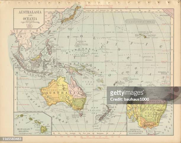


- Map,
- Antique,
- Indonesia,
- Australasia,
- Australia,
- Cartography,
- Chart,
- Engraved Image,
- Engraving,
- History,
- Horizontal,
- Illustration,
- Illustration Technique,
- King - Royal Person,
- Malaysia,
- New Zealand,
- Oceania,
- Old,
- Old-fashioned,
- Pacific Ocean,
- Paper,
- Papua New Guinea,
- Papua Province - Indonesia,
- Physical Geography,
- Politics,
- Politics and Government,
- Polynesia,
- Retro Style,
- Serbia,
- Tasmania,
- Textured,
- Western New Guinea,